

Under the Ice
Extracting winter algae samples to provide crucial information about the future of our planet’s freshwater.
2023 Trebek Grantee
Andrew Budziak
Andrew and team dive into icy waters to uncover vital clues algae hold about the future health of our planets freshwater ecosystems."
Follow the dangerous journey Under the Ice to uncover insights on future of our freshwater
2023 Trebek Grantee Andrew Budziak's project follows an elite team of ice divers in the Kenora region as they venture into some of the most hostile environments on Earth to collect winter algae samples.
These algae communities, crucial for understanding the health of freshwater lakes, were recently discovered living on ice ceilings during the winter months. Due to the challenging nature of accessing these samples, very few have been collected, and as ice coverage diminishes each year due to climate change, the window for studying them is closing.
Through breathtaking underwater cinematography and compelling storytelling, Andrew’s documentary will showcase the extreme conditions under which citizen science thrives, offering valuable insights into the future of our planet's freshwater ecosystems.
Searching for Insights on the Future of Freshwater
Hear Andrew explain what his team hopes to find Under the Ice

Principle of Two-Eyed Seeing
Mapping the Geo-Cultural Landscape
By its position along the edge of the Canadian Shield, Georgian Bay has been a crossroads of cultures since people first inhabited the shores of Glacial Lake Algonquin over 11,000 years ago. This marked the beginning of a long-lived interconnection between an evolving landscape and the Indigenous cultures, including the Huron-Wendat and Anishinaabe Peoples, who have called Georgian Bay home for thousands of years.
Embracing the principle of 'two-eyed seeing' means reconciling the Indigenous perspective and history with state-of-the-art mapping technologies. Our team utilized Light Detection and Ranging (LiDAR) technology to map geo-cultural sites and landscapes identified by local Indigenous partners, uncovering over 11,000 years of history in the landscape.
To provide a more comprehensive understanding of Georgian Bay's history, the project overlays Indigenous oral histories with the stories the landscapes reveal. By integrating the oral traditions of the Huron-Wendat and Anishinaabe Peoples with modern scientific findings, we preserve Indigenous knowledge and create a fuller picture of the past.

Between May and October 2023, Trebek Explorer Kirsten Kennedy and her team members and field assistants embarked on an extensive fieldwork journey across Georgian Bay. They visited geocultural sites in 4 primary locations including the historic region of Huronia, the Niagara Escarpment, the Killarney Peninsula, and the expansive 30,000 Island region.
The team collected LiDAR data, photographs, aerial imagery, video, and invaluable knowledge from local communities and Indigenous Elders. This comprehensive approach enabled the team to document the rich environmental and cultural history of these diverse regions.
To learn more scroll down or select one of the 4 fieldwork locations:
EXPLORER’S JOURNEY
FIELD NOTES
From May - Oct 2023, our team spent countless hours hiking, boating, flying drones, and setting up LiDAR equipment on rocky shores to uncover the hidden stories of Georgian Bay.

Team in field working in the 30,000 islands.

Drone support in the 30,000 islands required an appropriate landing spot with deep water to avoid boat grounding - and a terrain gentle enough to facilitate takeoff and landing. Then, we unpacked and set up the drone, established a GPS base station, and set up a battery charging station to enable multiple flights from the same location.

Drone in flight with the La Cloche Range in the background and pink Killarney Granites in the forefront.

Team members Kirsten Kennedy and Jamie Hunter, and team member Lillian O'Campbell Niell setting up for a drone flight near Wye Marsh. This flight collected data about a Wendat village called the "Forget Site" which has been partially excavated by archeologists.

Ground view of fieldwork. The team is walking along a ridge of uplifted beach cobbles. They are walking in the area shown from above in the next image.

A birds-eye view of the coast near Lighthouse Point, Killarney, showcasing a raised cobbly beach set back from the present shoreline. This feature serves as evidence of the continuous and ongoing uplift of the land as it recovers from being depressed under the weight of the last ice sheet. Evidence for occupation of the area in the past is therefore often located inland from the modern coast on these paleo-shorelines.

Field work Set Up - On the first day of our fieldwork near Henvey Inlet, we set up on a vivid orange rock (made so by a crust of sunburst lichen) at the mouth of Henvey Inlet. Our purpose was to map the complex waterways of the 30,000 islands region of Georgian Bay. Our boat engines caused pollen in the water to disperse into clouds leaving temporary yellow streaks.

Drone taking off to map islands outboard of Henvey Inlet. These islands are important because they shelter a complex network of waterways which have been used for navigation and sustenance for centuries.

Aerial Photo overlooking Key Harbour and the Henvey Inlet Wind facility. The Key River occupies one of many deep, linear gouges in the Canadian Shield that provide safe passages to the comparatively sheltered interior which was rich hunting and fur trapping grounds.

We used a DJI matrice 300 drone equipped with a LiDAR data collection system at sites across Georgian Bay.

Undertaking fieldwork in the 30,000 islands involved finding a suitable landing spot with deep water and gentle terrain for drone takeoff and landing. We unpacked and set up the drone, established a GPS base station, and set up a battery charging station for multiple flights. Then, we embarked on a reconnaissance walk to gain a ground-level perspective of the topographical features.

Drone taking off for a flight surveying subglacial meltwater channels and bedrock mega-grooves cut into the thirty-thousand islands.

TREBEK EXPLORERS DRIVE IMPACT IN 3 DIFFERENT WAYS
The Trebek Initiative was launched in 2021 to explore and celebrate Canada’s natural and cultural heritage.
Through storytelling, we illuminate the hopeful work our 38 Trebek Explorers are doing across Canada, with a goal to inspire future explorers and drive meaningful impact through Discovery, Engagement and Action.
Discover how Kirsten’s project delivered impact through:
DISCOVERY
Project Impact Through
In total, we performed 115 LiDAR flights around Georgian Bay, covering a diverse range of locations including the historic region of Huronia, the Niagara Escarpment, the Killarney Peninsula, and the expansive 30,000 island region.
Our explorations led us to 13 archaeological sites. Highlights include the St. Louis Jesuit mission, where Fathers Brebeuf and Lalemont were captured; Sainte Marie among the Hurons; the Ball site (circa 1600), one of the largest villages in Huronia; and the Ossossane and Cahiague sites, which were detailed by Champlain. We also investigated the Forget site, where archaeological excavations have left remarkable traces of longhouses and palisade walls.
Explore the 4 Areas Surveyed by LIDAR
Learn about an ancient engineering marvel and view the “mystery circle” uncovered by LIDAR.
Explore the exciting landscape and stories of the caves and waterfalls of the Niagara Escarpment.
Explore landscapes shaped by natural forces and the activity of the Anishinaabe Peoples.
Each island holds stories of ancient engineering, navigation, and adaptation of the Anishinaabe.
REGION OF HURONIA
Mnijikaning Fish Weirs
Ancient Engineering Marvel
Beneath the grass and mud of an unassuming waterway lies one of the most extraordinary archaeological sites in Ontario: the Mnijikaning Fish Weirs.
These ancient structures, radiocarbon-dated to 4,900 years old, offer a fascinating glimpse into the engineering prowess of early Indigenous peoples.
-
Design and Function: The Mnijikaning Fish Weirs consisted of hundreds of sharpened stakes organized into an array to trap fish swimming between Lake Couchiching and Lake Simcoe. These intricate designs were highly effective in sustaining local communities.
Historical Damage: Many of the stakes have been either removed for safekeeping or buried by silt. Unfortunately, a significant portion of the weirs was damaged by dredging activities aimed at widening and straightening the main waterway.
-
Champlain's Observations: In the early 17th century, Samuel de Champlain wrote about these weirs, noting that they were manned by the Huron-Wendat. This historical account provides valuable insight into the use and management of the weirs during that period.
Cultural Legacy: The weirs are now protected by the Rama First Nation. The Wendat referred to the weirs as "Ouentaronk," meaning "where there are sticks out of water." It is believed that this name, through a series of misattributions, led to the naming of "Toronto."

Mystery Circle in Wye Marsh Uplands: This irregular circle, crossed by three lines and enclosed in a rough rectangle, is unrelated to modern property lines or laneways. There is no obvious explanation from old structures or farming practices, and we do not believe it has any particular archaeological or historical origin.

Map outlining the 115 LiDAR flights we performed around Georgian Bay including sites in old "Huronia", on the Bruce Peninsula, on the Killarney Peninsula, and across the 30,000 island region

We visited 13 archeological sites, including, among others, the St. Louis Jesuit mission where Fathers Brebeuf and Lalemont were captured, Sainte Marie among the Hurons, the Ball site (ca. 1600) which was one of the biggest villages in Huronia, the Ossossane and Cahiague sites which were written about by Champlain.

Aerial Photo - Longhouse trace at Ossossane. This was the site of 2 Wendat villages of the Attignaouantan (Bear) Nation (1622-1638 and 1638-1649). In the grass, we can see a clear outline of a longhouse and several round middens (essentially rubbish pits).

Ultra high resolution digital elevation model derived from drone-LiDAR at "Cahiague". This archeological site was the location of two Wendat villages, but it has subsequently been ploughed and densely reforested. The elongate depressions that we see as a ground disturbance in the ground elevation data are the hollows of Wendat structures like longhouses.

This unassuming channel of Atherly Narrows is the original site of the Mnijikaning Fish Weirs. They have largely been removed for safekeeping, destroyed by ships grounding in the channel and various construction projects, or burried by silt, but it's fascinating to imagine a huge wooden contraption spanning across this channel.

The Mnijikaning Fish Weirs at Atherley Narrows are ancient fish trapping structures dating back over 4,900 years. These sophisticated weirs consisted of wooden stakes driven into the riverbed, creating barriers and channels to guide fish into enclosures where they could be easily harvested. This ingenious method highlights the advanced engineering and sustainable fishing practices of the Huron-Wendat Peoples.
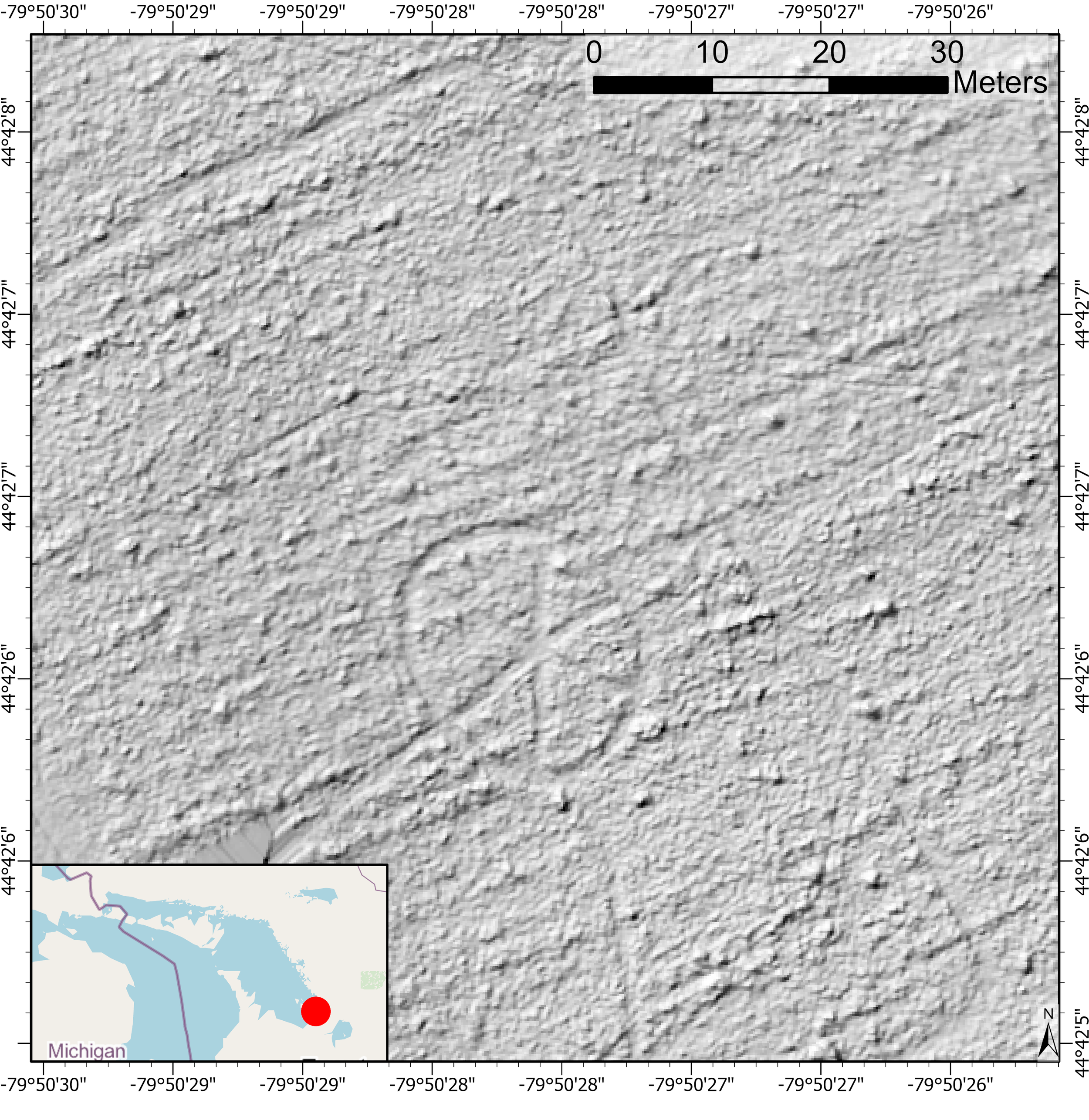
LiDAR-derived digital elevation model - Mystery Circle in Wye Marsh Uplands. LiDAR reveals that the mystery circle is indeed a measurable depression in the landscape and allows us to measure it's dimensions - 22.5 m across.
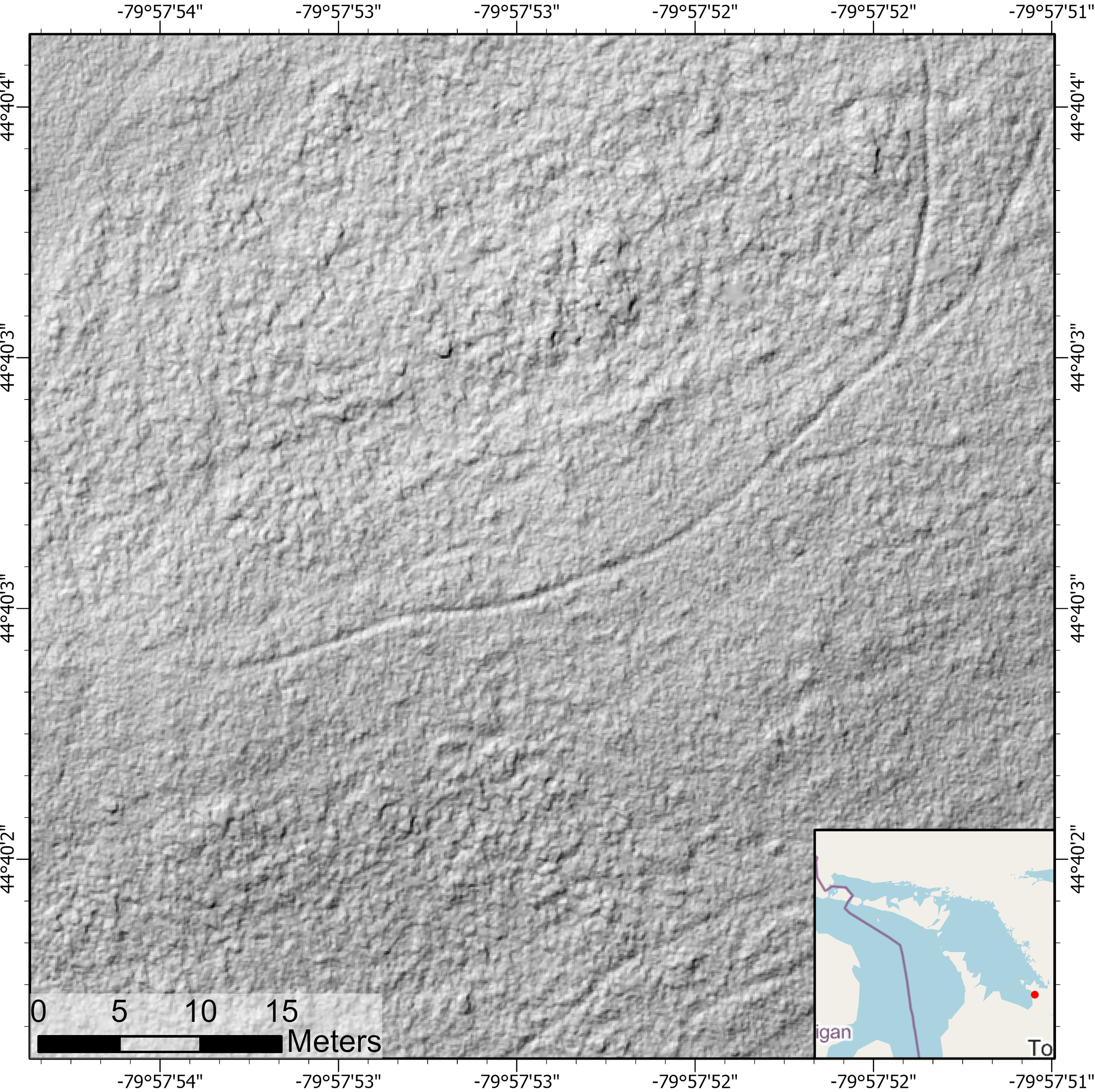
Ultra high resolution LiDAR at Ossossane. Ossossane is the site where Champlain observed and wrote about the 'feast of the dead,' and as such, is a historic site. This LiDAR image shows an area where an outline of a longhouse is apparent from the areal imagery.

LiDAR-derived digital elevation model of the St. Louis Mission (a National Historic Site). Though we don't see remains of the structures, LiDAR reveals the geomorphology of the stretch of the Hogg River Valley as it descends from the Simcoe Highlands down across the raised beaches of the falling Nippising-stage Lake Huron. Contains information licensed under the Open Government Licence – Ontario.
NIAGARA ESCARPMENT
Eugenia Falls
Sparkling Waters of Georgian Bay
Eugenia Falls, also known as “Sparkling Waters” or “Ke-waid-dun-dot,” stands at 30 meters, making it the tallest waterfall in the Georgian Bay Geopark. This breathtaking natural feature has a rich geological and cultural history, offering visitors a glimpse into the ancient forces that shaped the landscape and the myths surrounding it.
-
Cliffs and Hollows: The sheer cliffs of Eugenia Falls overhang hollows that reflect the positioning of tough Amabel Dolostone over the softer rocks of the Clinton-Cataract Group.
Ancient Rockfalls: Large boulders scattered along the valley floor are remnants of ancient rockfalls during the headward erosion process.
-
Chalcopyrite Confusion: Eugenia Falls was briefly at the center of a gold rush when the mineral Chalcopyrite was mistaken for gold. This historical episode adds an intriguing layer to the site’s history.
-
Serpent Myth: Local legend speaks of a serpent stirring the waters of the plunge pool, adding a mystical dimension to the natural beauty of Eugenia Falls.

Overlooking Hope Bay on the Bruce Peninsula. The area is called Nochemowenaing by the Saugeen Ojibway and is considered a place of healing. The projections of low-lying land into the Bay are particularly important culturally. They were formed through the redistribution and rearrangement of large slabs of rock by waves as lake level lowered. It has at least 2000 years of recorded Odawa archeology.

Eugenia falls is also known as as “Sparkling Waters” or “Ke-waid-dun-dot” and at 30 m is the tallest waterfall in the Georgian Bay Geopark. Sheer cliffs overhang hollows reflect the positioning of tough Amabel Dolostone over the softer rocks of the Clinton-Cataract Group. Large boulders lie along the valley floor and are the remnant of ancient rockfalls during the headward erosion process.

Looking down on the plunge pool of Eugenia Falls.
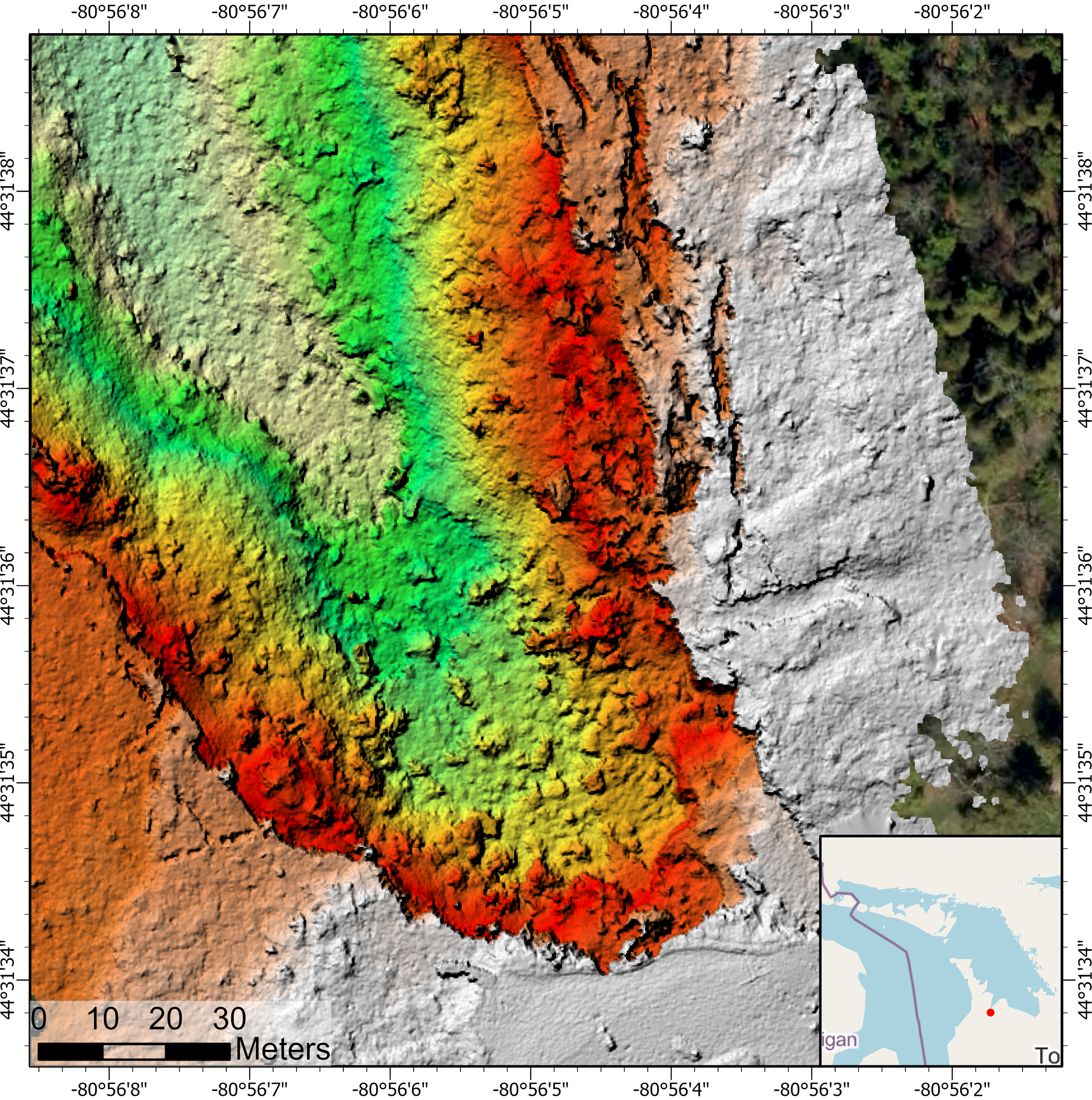
Ultra high resolution (20 cm grid) digital elevation model derived from drone-LiDAR at Inglis Falls showing the cambering of wallrocks into the gorge and opening of fissures. Boulders lay strewn along the valley bottom.

Ultra high-resolution LiDAR digital elevation model of a 'collapsed' cave. Perched sea caves, situated approximately 20 m above the modern level of Georgian Bay, are often found along the Niagara Escarpment. These were formed at lake level by the undercutting of cliffs by waves, much like what we see today at the popular tourist destination known as 'the grotto'. However, these older caves have been raised up out of the water by the post-glacial rebound of the land. The round hollow area in the middle of the image may be from a cave whose roof has collapsed.

LiDAR-derived Digital Elevation Model of Eugenia Falls showing the headwards erosion of the Cuckoo Valley away from the Beaver Valley. On the north side of the valley, the Gibraltar Moraine marks a prominent rise in the landscape. Contains information licensed under the Open Government Licence – Ontario
Grieg's Caves
A Journey Through Time and Geology
Nestled along the rugged landscape of the Bruce Peninsula, Grieg's Caves offer a fascinating glimpse into the geological and cultural history of the region.
Located on the shores of Georgian Bay, these caves are part of the Niagara Escarpment, a UNESCO World Biosphere Reserve renowned for its breathtaking cliffs and ancient forests.
-
The caves themselves are perched sea caves formed thousands of years ago when the water level was much higher.
Over millennia, relentless waves from what was then a glacial lake carved out these impressive formations, leaving behind a series of caves and overhangs.
Today, these caves sit approximately 20 meters above the modern water level, lifted by the gradual post-glacial rebound of the land.
-
The significance of the caves along the Niagara Escarpment extends beyond their geological formation.
The Grieg's caves are one of many caves long recognized by the Indigenous Peoples, particularly the Odawa, who regarded these caves as important spiritual sites.
The caves and surrounding landscapes were not only shelters but also places of cultural and ceremonial importance.
The intricate rock formations, echoing chambers, and natural amphitheaters created by the caves have inspired awe and reverence for generations.
-
Visitors to Grieg's Caves can explore this hidden world and experience the natural beauty and historical richness firsthand.
The caves' stunning rock formations, combined with their storied past, make them a compelling destination for adventurers, history enthusiasts, and nature lovers alike.
KILLARNEY PENINSULA

Killarney Bay. 2000 years ago, when the water stood about 7 meters higher than today, this viewpoint would have been looking down a channel that cut off the tip of the Killarney Peninsula into an island ("Spiegel Island"). A significant archeological site sits along the shores and is a window into "Middle Woodland" cultures that would have used these now dry channel as a transportation and trading corridor.

Killarney Channel, known by the Ojibwe name 'Shebahonaning' for Safe Canoe Passage. It owes it's geological origin to a fault running down the length of the passage. George Island sits several meters higher than Killarney Townsite.

Overlooking the town of Killarney. Flat Point, in the foreground, was once a traditional indigenous camp and trading post. Killarney township, in the midground, is thus situated because of a small patch of arable soil which was farmed by the first European settlers of Killarney.

A birds-eye view of the coast near Lighthouse Point, Killarney, showcasing a raised cobbly beach set back from the present shoreline. This feature serves as evidence of the continuous and ongoing uplift the land as it recovers from being depressed under the weight of the last ice sheet. Evidence for occupation of the area in the past is therefore often located inland from the modern coast on these paleo-shorelines.

Ground view of field work team walking along a ridge of uplifted beach cobbles shown from above in the previous image.

LiDAR-derived ultra-high resolution digital elevation model from the embayment near Lighthouse Point at Killarney (as in previous photo) showing multiple raised beaches which have been lifted out of the water by post-glacial rebound.

LiDAR-derived digital elevation model of Thebo Point shows details of the important eastern entrance to Shebonahing - the channel on which an important traditional indigenous campsite and trading post was located. At least three raised beaches visible in the data reflect the gradual and continuing rebound of the Killarney coastline.
THE 30,000 ISLANDS
Whistler Bay
Uncovering the Secrets of the Canadian Shield
This footage is from Whistler Bay near French River and captures the aftermath of the 2018 Parry Sound forest fire. This devastating fire cleared out dense forests, exposing the underlying shape of the landscape and revealing the geological wonders of the Canadian Shield.
Exploring Whistler Bay, you can witness the interplay between geological forces and cultural histories which shaped this extraordinary landscape. This site offers a unique window into the ancient past and the rich cultural narratives of the Indigenous peoples.
Discover the hidden stories of the Canadian Shield and the French River, and see how the landscape has evolved over billions of years.
-
Peneplain Formation: The Canadian Shield at Whistler Bay is remarkably flat, known as a "peneplain," having been worn level by a billion years of erosion. Large linear gashes in the landscape tell the story of this ancient geological process.
Grenville Orogeny: The rocks in this area were formed over a billion years ago during the Grenville Orogeny, a period that saw the rise of mountain belts rivaling the Himalayas. The surface has since been scoured and polished by fast-flowing ice and glacial meltwaters.
-
Navigable Route: The French River, flowing through this area, has been a crucial navigable route from Lake Huron to Lake Nipissing. It was used by Indigenous travellers for millennia and later by French Voyageurs during the fur trade.
Historical Encounters: It was near this river that Samuel de Champlain first encountered the "Cheveau Releve" (the Odawa), marking a significant historical event in the region.

Overlooking Key Harbour. The Key River occupies one of many deep, linear gouges in the Canadian Shield that provide safe passages to the comparatively sheltered interior, rich in hunting and fur trapping grounds. Often described as 'faults' due to their shape, they may be better described as 'fractures' since there is no obvious movement across them, and their age and origin are not well constrained.
Overlooking an island off of Bigbsy Island. The island is cut into two by a sinuous and deep meltwater channel that would have been scoured by pressurized, debris-laden water trapped underneath the Laurentide Ice sheet. Barely visible are several team members undertaking field reconnaissance to document the island on foot.

Ground photograph of the meltwater channel that cuts through an island

The Georgian Bay "Wave" near Bessener Island. This intriguing rock formation was carved by glacial meltwaters tunnelling through billion-year-old gneiss. Yellow clouds in the water are plumes of pollen collected in all embayments at that time of year.

Field work in the 30,000 islands.

A cluster of islands in the 30,000 islands. The rocks here are about 900 million years old and made of gneissic granodiorite with light-coloured igneous veins from the injection of magma. The rocks have been smoothed by glacial erosion.

LiDAR at 10 cm grid scaleshowing a swarm of whalebacks peaking out from the water surface. These glacial landforms were carved by fast-flowing ice.

Overlooking an island off of Bigbsy Island. The island is cut into two by a sinuous and deep meltwater channel that would have been scoured by pressurized, debris-laden water trapped underneath the Laurentide Ice sheet. Barely visible are several team members undertaking field reconnaisance to document the island by foot.

LiDAR dataset showing topography of an unnamed island near Bigsby Island.
ENGAGEMENT
Project Impact Through
It is important to engage with a diverse group of stakeholders, to ensure we capture and document Georgian Bay's rich geocultural history comprehensively. By working closely with Indigenous Elders, technical experts, and the local community, we’ve built a deeper connection to the land and its heritage.
This continued collaboration is key to informing our educational and conservation efforts while supporting the proposal for a UNESCO Global Geopark designation for the region.
Learn how the team:
-
We engaged with various sources and experts to collect comprehensive data for our project:
Collaborating with Indigenous Elders:
Our project deeply valued the knowledge of Indigenous Elders.
We held regular meetings and workshops where Elders shared their stories and traditional knowledge, providing essential context to our scientific data.
This collaboration helped us understand the historical significance of the sites we studied and ensured that the cultural heritage of the region was accurately represented.
Community Participation in Field Surveys:
We actively involved local community members in our field surveys and excavations.
This hands-on participation not only aided our research but also fostered a deeper connection between the community and the project.
Volunteers gained firsthand experience in archaeological methods and contributed to the preservation of their local heritage.
Engaging with Technical Experts:
We worked closely with a team of experts in LiDAR technology and archaeology.
These specialists brought a wealth of knowledge and experience, enabling us to utilize advanced techniques in mapping and analysis.
Their expertise ensured that our data collection was both accurate and comprehensive.
-
We were committed to sharing our findings with a broad audience through various platforms:
Educational Outreach: We extended our discoveries into educational settings, fostering intergenerational knowledge exchange. School screenings and community discussions ensured that younger generations learned directly from the experiences of their elders. This approach not only educated but also inspired a sense of pride and stewardship among the youth.
Interactive Workshops and Community Meetings: Our interactive workshops and community meetings allowed us to share our findings directly with local populations. These events were designed to be engaging and informative, fostering a deeper connection between the community and the project. Participants had the opportunity to ask questions, provide input, and learn more about the significance of the discoveries.
Digital and Social Media Platforms: We used digital and social media platforms to reach a wider audience. Regular updates on our project’s progress, key discoveries, and educational content were shared through our website and Instagram series. This approach ensured that our findings were accessible to people both within and outside the region. We also used these platforms to host live Q&A sessions and virtual tours, making our research more interactive and engaging.
-
Our project offered significant benefits to the region, enhancing its cultural and environmental heritage:
Supporting UNESCO Global Geopark Status: A key goal of our project is to support Georgian Bay’s bid for UNESCO Global Geopark status. This designation will celebrate the area’s unique geological and cultural heritage, promoting sustainable tourism and educational opportunities. Achieving this status will bring global recognition to Georgian Bay, encouraging further research and conservation efforts.
Promoting Sustainable Tourism: By highlighting the region's rich history and natural beauty, we aim to attract visitors interested in sustainable tourism. Our findings and educational initiatives provide valuable information that enhances the visitor experience, encouraging responsible and respectful engagement with the land.
Strengthening Community Ties: Our project fostered a sense of shared purpose and community pride. By involving local populations and Indigenous communities in our research and outreach efforts, we strengthened ties within the region. This collaborative approach ensured that the benefits of our work were felt broadly and contributed to the social and cultural cohesion of the area.
Enhancing Educational Resources: The educational materials and programs developed through our project serve as valuable resources for schools and community organizations. These materials help to preserve and disseminate knowledge about the region’s history, ensuring that it is passed on to future generations.
ACTION
Project Impact Through
-
LiDAR imagery has revealed previously unseen details of sites, providing a highly visual and accessible format.
This technology will be instrumental in creating informative guides for visitors, highlighting newly uncovered archaeological sites and geocultural landscapes.
Combined with the oral history provided by our Traditional Ecological Knowledge Elders, these guides will enrich tourism experiences, offering a deeper understanding and appreciation of the region’s history.
-
The results will inform the planning of the proposed UNESCO Global Geopark.
Detailed and accurate maps will help identify and protect significant geocultural sites, integrating them into the Geopark framework to enhance conservation efforts.
-
The data will support educational and conservation activities.
Findings will be made accessible to the public and educational institutions, fostering appreciation and understanding of the region’s history through workshops, interactive exhibits, and community programs.
-
The project has established a foundation for ongoing research and collaboration with Indigenous communities, local stakeholders, and academic institutions, ensuring traditional knowledge is respected and integrated into future initiatives.
Our work to date has demonstrated the powerful impact of LiDAR technology in revealing previously unseen details of the region’s physical and cultural landscape.
These insights will support efforts to secure UNESCO Global Geopark designation for the area which will help to enhance the educational and conservation activities across Georgian Bay.
The key actions from this project:
What is Lidar?
LiDAR (Light Detection and Ranging) is a remote sensing method that uses light in the form of a pulsed laser to measure variable distances to the Earth. These light pulses generate precise, three-dimensional information about the shape of the Earth and its surface characteristics.
We used LiDAR to capture high-resolution data of the landscape, revealing hidden historical and geological features that are not visible to the naked eye.
How did we use it?
The team encountered challenges such as dense vegetation and difficult weather conditions, which sometimes interfered with LiDAR data collection. Additionally, processing the large volumes of data required significant time and computational resources to ensure accuracy and detail.
Any Troubles?
Want to learn even more?
Just ask the Maple Mentor anything you are curious about learning more about!
MEET THE TEAM
-

Kirsten Kennedy
2023 TREBEK GRANTEE
Leading the project using UAV-borne LiDAR, developing geological and paleoenvironmental narratives, creating educational programming.
-

Jack Contin
TRADITIONAL ECOLOGICAL KNOWLEDGE ELDERS
Advising on Indigenous content, facilitating discussions with Indigenous organizations and stakeholders, identifying and classifying geo-sacred sites for conservation.
-

Nicholas Eyles
GEOSPATIAL ANALYSIS EXPERT
Over 40 years of experience in geospatial analysis, leading geology research projects, creating educational and public geology publications.
-

Jamie Hunter
ARCHAEOLOGICAL EXPERT
Expertise in Huron-Wendat and early European colonization archaeology, facilitating access to important archaeological sites.
-

Peter Storck
PALEOINDIAN PERIOD EXPERT
Expert on the Archaic period in Georgian Bay and Ontario, advising on locations for LiDAR mapping, and potential for discovering culturally significant sites.

WHAT’S NEXT?
Working in partnership with the Turtle Island Educational Center, we aim to collect stories from Indigenous knowledge keepers to consolidate geomythology for the geographic region of Georgian Bay. To date, we have compiled a database with about 55 sites or regions with strong geocultural stories that form the backbone of the project to develop a UNESCO Global Geopark.
Our plans include creating time-maps of the shifting paleoenvironments of Georgian Bay over the last 10,000 years. These time-maps will be instrumental in the development of the UNESCO Global Geopark, showcasing the dynamic history and rich cultural heritage of the region.
-
Workshops: Conduct workshops with Indigenous Elders and local communities to share findings and gather more traditional knowledge.
Educational Programs: Develop educational materials for schools and community groups to highlight the significance of discovered sites.
-
Geocultural Database: Utilize the compiled database of 55 geocultural sites to support the UNESCO Global Geopark application.
Time-Maps: Create time-maps illustrating the shifting paleoenvironments of Georgian Bay over the past 10,000 years.
-
Exhibitions: Develop public exhibitions to showcase project discoveries.
Digital Archives: Create digital archives to provide global access to the project's findings.
-
LiDAR Technology: Continue using LiDAR technology to explore and uncover more historical and cultural sites within Georgian Bay.
Geomythology Integration: Integrate stories from Indigenous knowledge keepers into the geocultural narrative of the region.
Follow us on Instagram
For more inspiring stories and discoveries from the Trebek Initiative.
Stay informed about groundbreaking projects like Kirsten's and witness the journey of exploration, innovation, and hope that illuminates and inspires appreciation for Canada's rich natural and cultural heritage.





Check out more exciting Trebek Explorer Feature Projects (Coming Soon)
-
![]()
Fighting Fire with Food
Returning Indigenous Fire Stewardship to British Columbia
Kira Hoffman's project, "Fighting Fire with Food," supports the Gitanyow Nation in returning to cultural burning practices after more than 100 years of suppression. Partnering with the British Columbia government and the University of British Columbia, the project combines traditional Indigenous knowledge with modern scientific methods to restore the land, enhance biodiversity, and ensure food security. This initiative highlights the benefits of cultural burning and promotes its integration into contemporary fire management strategies, demonstrating the importance of Indigenous practices in ecological restoration
-
![]()
Two-Eyed Seeing
Mapping the Geocultural Landscape of Georgian Bay
2023 Trebek Grantee Kirsten Kennedy's project, "Two-Eyed Seeing," combines Indigenous knowledge with LiDAR technology to uncover and document Georgian Bay's rich geocultural history. For Kirsten, geology isn't just about studying rocks; it's about uncovering the stories they tell about the region's history and its people. By integrating traditional Indigenous knowledge with modern technology, Kennedy reveals hidden stories in the landscape, supporting the bid for UNESCO Global Geopark designation and fostering a deeper connection to Georgian Bay's past and heritage.
-
![]()
Beyond Her Horizons
An All-Female Expedition Across the Northwest Passage
Jessica Houston's project, "Beyond Her Horizons," is an all-female polar expedition through the Northwest Passage, celebrating female contributions to the Arctic . Along with Okalik Eegeesiak and her crew, they sailed 5,400 km, visiting five remote communities and uncovering stories of women who have shaped the Arctic. The project challenges colonial narratives and highlights the contributions of women in Arctic exploration, showcasing diverse voices often overlooked in historical accounts.


